%20-%20Edit-01.png)

Solo Mountainpack
- Oct 26, 2022
- 9 min read
Sit in the dirt.
Watch leaves flutter by.
Sing to the bears.
Stargaze under the night sky.
Eat snacks.
Soak in the alpenglow.
Give the moon a kiss.
Pedal with your own flow.
It’s been a season full of silver linings. I had a lush list of events I wanted to tackle, however, my body had differing plans. Many bikepack routes, races and community events were put on hold as I recovered from some health issues and injuries. I am, however, truly grateful for how the season played out. It taught me to leave space for rest and recovery and to bask in my own adventures.
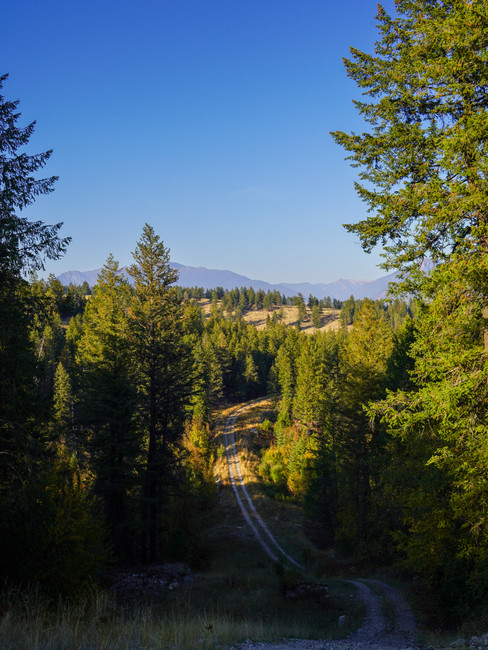
One of these adventures was my bikepack through the Rockies at the beginning of October. The weather was still unseasonably warm and the fall colours still prime, so I headed out on a solo meander. This wasn’t my first time bikepacking by myself, but it was my first time biking solo in a remote area of the mountains. I felt okay about the remoteness since I had my satellite communicator on me - allowing me to check in with designated friends, relay my riding progress, and hit that SOS button if absolutely needed.
I had been eyeing a Bikepacking in the Canadian Rockies Guidebook route for some time and decided it was a good fit for this weekend. I originally planned on doing the “Top of the World” route over a leisurely four days, but then work got busy and I decided three days was manageable.
Day 1 - Hey Bear - 82 km and 1,500 m
I started my bikepack rather late because of a combination of things. First, I purposely slept in, catching up on some sleep. Second, as I was driving to the start in Cranbrook, I realized I had no desire to start my bikepack on a long and busy stretch of highway. I drove back north and parked at a gas station in Fort Steele, telling myself I’d deal with the highway at the end of the trip instead.
So here I was, starting a mega bikepack at lunchtime. I wasn’t worried, though. I’d just pedal as far as I could and then lay my head down; tomorrow I could catch up.
The first 30 kilometres of my ride were straight up, with over 1,000 metres in elevation gain. I mosied my way up to Wild Horse Ridge on a mixture of smooth gravel roads and rocky, sandy track. There was lots of talking to the bears on the narrowed paths. I made it to the ridge and messaged my friend an update on my progress - slow.


Next up was over 30 kilometres of downward trending terrain, interspersed with a few creek crossings. I precariously crossed with my shoes still on; mostly successful with my tactical footsteps. One foot got slightly immersed with a misstep.


The Lussier River was mesmerizing in the twilight. I couldn’t possibly camp 60 km into my day, but gave myself permission to watch the sunset and then continue up a small climb. I entered Whiteswan Provincial Park in complete darkness, skirting Alces and Whiteswan Lakes, dreaming about what they would look like in daylight. It was in this darkness that my senses were heightened, more than once caught off guard by the rustle of my own jacket.
There was a dock on Whiteswan Lake that I took advantage of - filtering some water and rehydrating a meal. I debated setting up my bivvy on the dock too, but again, decided I should keep riding for a bit more.


A mere 5 kilometres from the dock was the Inlet Creek Campsite. I pulled into the grounds and did a quick survey of the situation. It looked like a parking lot with tents around the perimeter. I’d get little to no sleep surrounded by people, so kept on pedalling. Just up another hill, I found a small, open field bounded by trees. It didn’t have any signage but looked like a rec site. It even had a picnic table and a faulty bear hang setup.
I slowly got my sleep system set up, ate my meal a fair distance away and hung my bear bag in the woods, all the while narrating my intentions to the creatures of the night. With a clear sky, I still ducked my head inside the bivvy until I realized my breath was causing too much condensation. It was a chilly night. I could have done with another layer or two besides my sleeping bag rated for 0 degrees Celsius.
Day 2 - Fall Paradise - 109 km and 1,600 m
My alarm went off several hours later, prompting me to start my day in the dark morning dew. It was still brisk, and I didn’t want to get out of my sleeping bag. Before eating breakfast, I packed everything up but my damp wool clothes and fresh pair of bibs. I had a dehydrated breakfast bowl that had been soaking in the bear bag overnight. Normally I find the quinoa-based bowl refreshing, but this morning all I could do was gag. Literally spitting contents back into the meal packet. Thankfully, it was just the olives in the meal I couldn’t stomach, and I could eat an energy bar no problem.

I pedalled off into the darkness, excited to catch the alpenglow. It turned out to be one of those days where I stopped repeatedly, pulled out my small cushion and sat, watching the amber leaves flutter in the wind. My slow pace was a good indicator of how much I was enjoying the route. The section between Whiteswan Provincial Park and Fernie, following the Bull River and Sulphur Creek, was some of the prettiest riding I’ve ever done.


Dinner time was encroaching as I rolled into Fernie. I grabbed A&W as my first dinner, intending to pack a Lunchbox wrap for second dinner. To my dismay, the restaurant was closed because of staffing shortages. There wasn’t much open, so I waited for a chicken sandwich at the Brickhouse while daylight ticked away.

I hit the road towards Flathead Ridge, completely forgetting about the previous fall’s flooding and washout. The ‘Road Closed’ sign hit me abruptly. I still had cellular service, so blasted a few texts to local friends about my route and whether it was passable. By the time we reached a consensus, it had sunk in that it was foolish for me to embark on such a significant climb in the dark in cold weather. I texted Alex to check if I could stay the night instead and figure out a route I was more comfortable with.
As soon as I got to Alex’s house, I ate my second dinner, showered, did laundry, and gave Miso pets. I wasn’t out to set any stubborn records of nights camped in the wilderness, so this was a welcoming change to my plans. Alex also helped me plan a route for the following day, cutting out Flathead Ridge and most of the highway from Cranbrook to Fort Steele. This way, I’d make it back to my car and home in a reasonable time.


Day 3 - Trespass Adjacent - 147 km and 1,500 m
I awoke around 5 am, eager to grab a breakfast sandwich from Mc Donald’s upon opening hour. The paved roads out of town were a pleasant treat, but I let my guard down, not singing to the bears. A toddler bear scrambled up a bank as I whizzed by. As the sun lifted, an enchanting glow hit all the leaves, while a dense fog hovered near the ground. I once again stopped to take several photos. “Just one more”, I kept telling myself.

It was a downward trend to Elko on a gravel road shared with logging trucks. I was careful to keep my ears open and pull over on a whim. Elko set off a bunch of unfond memories of the Alberta Rockies 700 (last summer my friends and I had biked for 6 hours in the cold, pouring rain to get to Elko, hovering at a bus stop, figuring out our next steps). Thankfully, this time the sky was clear, and I was warm. My route had me going along a road that was clearly a logging yard, so I turned around and followed the public road to the highway.


The turnoff to the Trans Canada Trail was hidden on a descent along Highway 93 that I overshot, so I dipped into what appeared to be a driveway, hoping to connect. I hopped off my bike and walked towards the back of the property. I was prepared to chat with an owner, however, there was no structure on the property that I could see. The Trans Canada Trail was lovely and reminded me of the grasslands I had fallen for last summer, despite the miserable weather.


Continuing with my practice of slowing down and absorbing what the route offered, I stopped at another dock on Koocanusa Lake, staring out into the mountains while I snacked. I paralleled the Kootenay River to Wardner for some time. It was a cute little town, and I wondered to myself how much land would cost there.
It was around this time that I realized my rear tire was spraying sealant everywhere. I used some water to locate the hole in the tire and plugged it with my Dynaplug. Would it hold? Only time would tell.


To get from Wardner to the Chief Isadore Trail, I had snapped a few lines on Ride with GPS, assuming they were public. False assumption. Again, I turned onto what appeared to be a driveway that would connect to some ATV trail. I veered off the driveway onto a grassy path that lead towards a gate… only I was on the wrong side of the gate. Having had more time, I would have backtracked and taken some public roads, but since I was in a pinch, I hopped the waist-level fence and heaved my bike over from the other side. I remember being impressed that I could lift it that high. I was wondering in the back of my head if I’d encounter another fence at the end of the trail, but I never did. It was on this section of trail that a bull elk leaped across, hiding in the trees on my right side. From there on, my ‘hey bear’ calls turned to ‘hey elk’ calls.


The Cranbrook Gravel Grind race had happened two days prior, using the Chief Isadore Trail, so I was eager to check it out. It was so flowy! I couldn’t believe there was 30 kilometres of this dreamy terrain. For some time I had ridden without seeing a soul, so pulled over to pee in the woods. Of course, as soon as I propped my bike up against a tree, a fellow rider on a fat bike kitted out with a few bags came rolling by. Melanie was excited to see another female out bikepacking. We exchanged some words and then headed off in opposite directions.
At this point, I was out of water. The day had been filled with creek crossings, which suddenly vanished in this area. I put in a hard effort to get to the creek Melanie had described. I was happy to filter some water, sit creekside, and eat some snacks while restoring my energy. A short while later, Melanie made another appearance and sat down to brew some coffee. We chatted more about bikepacking and adventures, and how her mother too was still worried when she went off wandering.
We parted ways, and I headed out on my home stretch. I pedalled along a flat trail for some time until I came across a young cow that seemed to be stuck on the wrong side of the cattle guard and fence. I was heartbroken. No matter how calmly I talked to it, walked, or slowly biked, it still frantically ran away down the trail instead of going off to the side in the forest while I passed. After what felt like forever (maybe two minutes), the little cow finally ducked into the woods and I went by.
Based on the map Alex and I had put together and the beta from Melanie, I had now reached my shortcut to avoid highway riding. I wasn’t expecting another fence. This one had a chain wrapped around the fence and post and no lock. Perhaps its only function was to keep cows out? I opened the gate and scrambled to the other side, closing it tightly behind me. The next bit of trail was really fun to ride. Bonus - I popped out the other side without another fence crossing. I pedalled along Crowsnest Highway for a few minutes and then turned off onto a quiet road that kept me off the main highway for some time.
I made it back to the gas station before sunset, eager to stock up on some fuel. Two chocolate milks, water and spicy chips to keep me awake on my drive home.


I had such an amazing weekend out in nature by myself, besides my brief interactions with others in Fernie. It felt empowering to embark on a remote route on my agenda. Something I will most definitely do again!
Great read! If you’re looking to strengthen your online visibility, you should check out SEO Dublin. Their team offers tailored strategies that really help businesses climb the search rankings and attract the right audience.